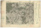
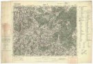
Neueste Karte von der Moldau, Walachei, Bessarabien un der Krim
description
Kolor. 46 x 69 cm na listu 60 x 83 cm Měřítko [ca 1:1 520 000]. 7,5 cm = 15 geographische oder deutsche Meilen 15 auf einen Grad = 100 Werst (022°10´13" v.d.--035°47´36" v.d./049°45´35" s.š.--043°04´07" s.š.)
- institution
- Mapová sbírka Přírodovědecké fakulty UK v Praze
- subcollection
- Mapová sbírka
- type
- Mapy
- alternate name
- Carte nouvelle de la Moldavie, Valakie, Bessarabie, et de la Crimée :
- subject author
- Schütz, Carl;Schmid, J. F.
- date of issue
- 1780-1800
- document publisher
- Johann Cappi
- language
- Němčina
- origin
- Rakousko, Wien
- material
- Papír
- original owner
- Geographisches Institut der Deutschen Universität in Prag
- inventory number
- 1296591
similar subjects
-
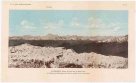 Mapová sbírka Přírodovědecké fakulty UK v PrazeGaurisankar (Mount Everest) und die Nepal-Alpen vom Südsporn des Kinchinjunga (in der Nähe des Chumbab La) aus Osten gesehen
 -
 Mapová sbírka Přírodovědecké fakulty UK v PrazeAllgemeiner grosser Schrämblischer Atlass
 -
 Mapová sbírka Přírodovědecké fakulty UK v PrazeAllgemeiner GROSSER ATLASS
 -
 Mapová sbírka Přírodovědecké fakulty UK v PrazePříbram
 -
 Mapová sbírka Přírodovědecké fakulty UK v PrazePlzeň
 -
 Mapová sbírka Přírodovědecké fakulty UK v PrazeReims (Châlons s. Marne)
 -
 Mapová sbírka Přírodovědecké fakulty UK v PrazeBrünn
 -
![[Ioannina]](/data/cache/media/e2/12268330-136x110-1707323888.jpg) Mapová sbírka Přírodovědecké fakulty UK v Praze[Ioannina]
Mapová sbírka Přírodovědecké fakulty UK v Praze[Ioannina] -
![[Lefkada]](/data/cache/media/38/12268315-136x110-1707323888.jpg) Mapová sbírka Přírodovědecké fakulty UK v Praze[Lefkada]
Mapová sbírka Přírodovědecké fakulty UK v Praze[Lefkada]