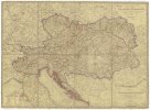
Karte von Ermeland oder zweites Blat von Westpreussen.
description
Mědiryt, kolor. 46,5 x 54 cm na listu 51 x 59 cm Měřítko [ca 1:225 000]. 6,6 cm = 2 geographische oder deutsche Meile (019°22´17" v.d.--021°14´31" v.d./054°30´07" s.š.--053°43´10" s.š.)
- institution
- Mapová sbírka Přírodovědecké fakulty UK v Praze
- subcollection
- Mapová sbírka
- type
- Mapy
- date of issue
- 1789
- document publisher
- F.A. Schraembl
- language
- Němčina
- origin
- Rakousko, Wien
- material
- Papír
- inventory number
- 001367861
similar subjects
-
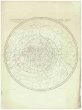 Mapová sbírka Přírodovědecké fakulty UK v PrazeStereographischer Entwurf des Gestirnten Himmels
 -
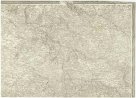 Mapová sbírka Přírodovědecké fakulty UK v PrazeTopog. Carte von Kriegs-Schauplatzes am Rhein und angränzenden Ländern von Deutschland und Frankreich
 -
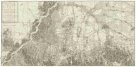 Mapová sbírka Přírodovědecké fakulty UK v PrazeNeuster Grundrißs der Haupt und Residenzstadt Wien und der umliegenden Gegenden
 -
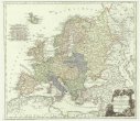 Mapová sbírka Přírodovědecké fakulty UK v PrazeKarte von Europa nach dem D'Anville und Has neu verzeichnet
 -
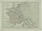 Mapová sbírka Přírodovědecké fakulty UK v PrazeKarte von Frankreich
 -
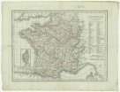 Mapová sbírka Přírodovědecké fakulty UK v PrazeFrankreich
 -
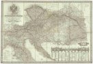 Mapová sbírka Přírodovědecké fakulty UK v PrazeNeueste General- Post- und Straßen Karte der Oesterreichischen Monarchie
 -
 Mapová sbírka Přírodovědecké fakulty UK v PrazeOestreichs Laender unter den Roemern
 -
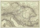
 Mapová sbírka Přírodovědecké fakulty UK v PrazeKarte der Oesterrechischen Monarchie