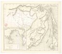
Montfort sheet of the lead and zinc district
description
Barev. 51 x 40 cm na listu 59 x 48 cm, vloženo v papírové obálce 22 x 26 cm Měřítko [ca 1:15 900]. 10,1 cm = 1 mile = 4 inches (090°29´28" z.d.--090°22´51" z.d./043°01´47" s.š.--042°56´17" s.š.)
- institution
- Mapová sbírka Přírodovědecké fakulty UK v Praze
- subcollection
- Mapová sbírka
- type
- Mapy
- alternate name
- Montfort sheet.
- subject author
- Steidtmann, Edward;Wisconsin Geological and Natural History Survey
- date of issue
- 1909
- document publisher
- Wisconsin Geological and Natural History Survey
- language
- Angličtina
- origin
- USA, Madison, Wis.
- material
- Papír
- inventory number
- 1404790
similar subjects
-
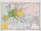 Mapová sbírka Přírodovědecké fakulty UK v PrazeEurope at the time of Napoleon.
 -
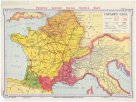 Mapová sbírka Přírodovědecké fakulty UK v PrazeCaesar's Gaul.
 -
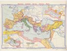 Mapová sbírka Přírodovědecké fakulty UK v PrazeRoman empire
 -
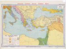
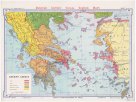 Mapová sbírka Přírodovědecké fakulty UK v PrazeAncient Greece
 -
 Mapová sbírka Přírodovědecké fakulty UK v PrazeThe Achaean world
 -
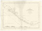 Mapová sbírka Přírodovědecké fakulty UK v PrazeMap of Liberia
 -
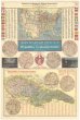 Mapová sbírka Přírodovědecké fakulty UK v PrazeMapa Spojených států S. A. s označením českých osad a Republiky československé
 -
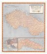 Mapová sbírka Přírodovědecké fakulty UK v PrazeMapa Československa
 -
 Mapová sbírka Přírodovědecké fakulty UK v PrazeKarta Amurského a Přímorského kraje