Special-Karte der europäischen Türkei
description
Kolor. 36,5 x 49 cm, sestavená 219 x 245 cm, na listech 45 x 58 cm + Měřítko 1:600 000. 4,9 cm = 4 deutsche Meilen, 15 = 1°= 4 österreichische Meilen, (a 4000 w. Klftr.) 14,67 = 1°. 5,2 cm = 4 moldau-walachische Meilen, 14,16 = 1°. 4,4 cm = 6 türkische Aghatsch, 25 = 1°. 5,3 cm = 30 russische Werst, 104,32 = 1° (014°22´12" v.d.--029°37´08" v.d./049°00´32" s.š.--037°07´31" s.š.)
- institution
- Mapová sbírka Přírodovědecké fakulty UK v Praze
- subcollection
- Mapová sbírka
- type
- Mapy
- subject author
- Flemming, C.
- date of issue
- 1850-1880
- document publisher
- C. Flemming
- language
- Němčina
- origin
- Polsko, Glogau
- material
- Papír
- original owner
- Razítko Malonice.
- inventory number
- 1357780
similar subjects
-
![[Prusische Kreise]](/data/cache/media/32/11878894-136x110-1707323637.jpg) Mapová sbírka Přírodovědecké fakulty UK v Praze[Prusische Kreise]
Mapová sbírka Přírodovědecké fakulty UK v Praze[Prusische Kreise] -
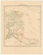 Mapová sbírka Přírodovědecké fakulty UK v PrazeTunis u. westl. Theil von Tripoli
 -
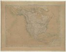 Mapová sbírka Přírodovědecké fakulty UK v PrazeNord America
 -
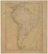 Mapová sbírka Přírodovědecké fakulty UK v PrazeSüd-Amerika
 -
 Mapová sbírka Přírodovědecké fakulty UK v PrazePost- & Reise- Karte von Deutschland und den nachbar Staaten
 -
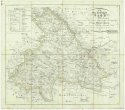 Mapová sbírka Přírodovědecké fakulty UK v PrazeDie Grafschaft Glaz in zwei Abtheilungen zum Breslauer Regierungs Bezirg gehörig.
 -
Mapová sbírka Přírodovědecké fakulty UK v PrazePost- und Reise-Karte von Deutschland und den nachbar Staaten
-
 Mapová sbírka Přírodovědecké fakulty UK v PrazePlan miasta Krakowa w obrębie okopów
 -
 Mapová sbírka Přírodovědecké fakulty UK v PrazeProvinz Sachsen und Herzogthümer Anhalt