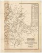
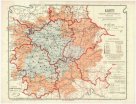
Karte des Bezirkes Komotau
description
Litografie, čb. sestavená 59 x 81 cm, na listech 64 x 50 cm Měřítko [ca 1:36 000]. 10,5 cm = 2000 W. K. (013°17´03" v.d.--013°36´02" v.d./050°31´13" s.š.--050°22´02" s.š.)
- institution
- Mapová sbírka Přírodovědecké fakulty UK v Praze
- subcollection
- Mapová sbírka
- type
- Mapy
- subject author
- Hollmann, Victor Josef;Mecséry de Tsóor, Karl Johann
- date of issue
- 1863
- document publisher
- Friedrich Selner
- language
- Němčina
- origin
- Ústecký kraj, [Žatec]
- material
- Papír
- literature
- Roubík 2,
- inventory number
- 1388219
next subjects
-
 Mapová sbírka Přírodovědecké fakulty UK v PrazeKarte des Bezirkes Podersam
 -
 Mapová sbírka Přírodovědecké fakulty UK v PrazeKarte des Bezirkes Postelberg
 -
 Mapová sbírka Přírodovědecké fakulty UK v PrazeKarte des Bezirkes Pressnitz
 -
 Mapová sbírka Přírodovědecké fakulty UK v PrazeKarte des Bezirkes Tetschen
 -
 Mapová sbírka Přírodovědecké fakulty UK v PrazeKarte des Bezirkes Tetschen
 -
 Mapová sbírka Přírodovědecké fakulty UK v PrazeKarte des Saazer Hopfenbaugebietes
 -
 Mapová sbírka Přírodovědecké fakulty UK v PrazeKarte des Saazer Kreises im Koenigreiche Boehmen
 -
 Mapová sbírka Přírodovědecké fakulty UK v PrazeKarte des Saazer Kreises im Koenigreiche Boehmen
 -
 Mapová sbírka Přírodovědecké fakulty UK v PrazeKarte des Saazer Kreises im Königreiche Böhmen