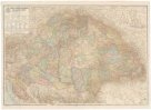
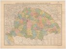
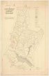
A Magyar korona országainak az 1876ik évi XXXIII. törvényczikk szerinti közigazgátasi beosztása
description
Kolor. litografie 55 x 82 cm na listu 63,5 x 92,5 cm Měřítko 1:1 152 000 (014°30´07" v.d.--026°14´07" v.d./049°32´22" s.š.--043°04´07" s.š.)
- institution
- Mapová sbírka Přírodovědecké fakulty UK v Praze
- subcollection
- Mapová sbírka
- type
- Mapy
- alternate name
- Karte der neuen politischen Eintheilung von den zur ungarischen Krone gehörigen Ländern
- subject author
- Hátsek, Ignaz,Keleti, Karl
- date of issue
- 1876
- document publisher
- Carl Louis Posner
- language
- Maďarština
- origin
- Maďarsko, [Budapešť]
- material
- Papír
- original owner
- Podpis K Kořistka 876
- inventory number
- 001397396
next subjects
-
 Mapová sbírka Přírodovědecké fakulty UK v PrazeA Magyar korona országanaik közigazgatási térképe
 -
 Mapová sbírka Přírodovědecké fakulty UK v PrazeA Magyar szt. korona országainak közigazgatási és közlekedési térképe
 -
 Mapová sbírka Přírodovědecké fakulty UK v PrazeA Magyar Állam közigazgatási térképe
 -
 Mapová sbírka Přírodovědecké fakulty UK v PrazeA Maygar szent korona országainak földmivelési térképe
 -
 Mapová sbírka Přírodovědecké fakulty UK v PrazeA Németmokrai m kir erdögondnokság "A B" és "C" gazdasági osztályainak átnézeti térképe
 -
 Mapová sbírka Přírodovědecké fakulty UK v PrazeA Szerb háború térképe
 -
 Mapová sbírka Přírodovědecké fakulty UK v PrazeA felvidék közigazgatási térképe
 -
 Mapová sbírka Přírodovědecké fakulty UK v PrazeAbauj-Torna vármegye
 -
 Mapová sbírka Přírodovědecké fakulty UK v PrazeAbauj-Torna vármegye térképe