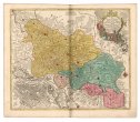
Karte von Europa und dem Mittelländischen Meere
description
Barev. 87 x 110 cm Měřítko [ca 1:4 300 000] (025°45´07" z.d.--062°29´24" v.d./071°21´25" s.š.--024°22´01" s.š.)
- institution
- Mapová sbírka Přírodovědecké fakulty UK v Praze
- subcollection
- Mapová sbírka
- type
- Mapy
- date of issue
- 1871
- document publisher
- Justus Perthes
- language
- Němčina
- origin
- Německo, Gotha
- material
- Papír
- inventory number
- 001265929
similar subjects
-
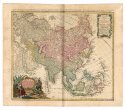 Mapová sbírka Přírodovědecké fakulty UK v PrazeAsia
 -
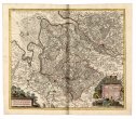 Mapová sbírka Přírodovědecké fakulty UK v PrazeNova Et Accuarata Descriptio Ducatus Bremae et Ferdae cum Maxima parte finitimi Ducatus Stormariensis Et Comitatus Oldenburgici, Itemque Fluminum Albis Et Visurgis
 -
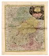 Mapová sbírka Přírodovědecké fakulty UK v PrazeBavariae Circulus et Electoratus In Suas Quasque Ditiones tam cum Adiacentibus Quam Insertis Regionibus accuratißime divisus ...
 -
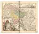 Mapová sbírka Přírodovědecké fakulty UK v PrazeTabula Ducatus Carnioliae Vindorum Marchiae et Histriae
 -
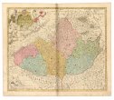 Mapová sbírka Přírodovědecké fakulty UK v PrazeTabula Generalis Marchionatus Moraviae In Sex Circulos Divisae
 -
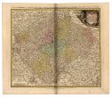 Mapová sbírka Přírodovědecké fakulty UK v PrazeBohemiae regnum in XII circulos divisum
 -
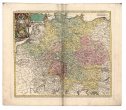 Mapová sbírka Přírodovědecké fakulty UK v PrazeImperii Romano-Germanici In Suos Status Et Circulos Divisi Tabula Generalis
 -
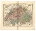 Mapová sbírka Přírodovědecké fakulty UK v PrazeHelvetia Tredecim Statibus Liberis
 -
 Mapová sbírka Přírodovědecké fakulty UK v PrazeNova mappa geographica totius Ducatus Silesiae