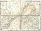
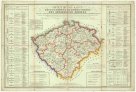
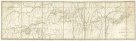
Geognostische Karte des Königsreichs Böhmen
description
Barev. 32 x 43 cm Měřítko [ca 1:1 020 000]. 10,8 cm = 15 deutsche Meilen (011°38´43" v.d.--017°30´43" v.d./051°06´12" s.š.--048°25´45" s.š.)
- institution
- Mapová sbírka Přírodovědecké fakulty UK v Praze
- subcollection
- Mapová sbírka
- type
- Mapy
- subject author
- Preininger, Andreas;Biller, Dominicus
- date of issue
- 1841
- language
- Němčina
- origin
- Evropa
- material
- Papír
- inventory number
- 1289134
next subjects
-
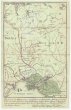
 Mapová sbírka Přírodovědecké fakulty UK v PrazeKriegsstrassen Karte eines Theiles von Russland und der angraenzenden Laender
 -
 Mapová sbírka Přírodovědecké fakulty UK v PrazePlan von der Krim und der Nogdyschen und Kubanschen Tatarey
 -
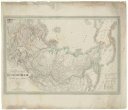
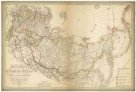 Mapová sbírka Přírodovědecké fakulty UK v PrazeGeneralcharte des Russischen Reichs in Europa, Asien und America
 -
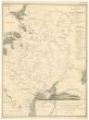 Mapová sbírka Přírodovědecké fakulty UK v PrazeCarte hydrographique de la principale partie de la Russia Europeenne.
 -
 Mapová sbírka Přírodovědecké fakulty UK v PrazeGeneral Charte von Russischen Reiche in Europa, Asien und America
 -
 Mapová sbírka Přírodovědecké fakulty UK v PrazeOrientirungs-Karte in der neuen gerichtlichen und politischen Eintheilung des Königreich Böhmen
 -
 Mapová sbírka Přírodovědecké fakulty UK v PrazeMaehren und Oesterreichisch Schlesien, mit Benützung aller astronomischen und geografischen Hilfsmittel
 -
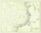 Mapová sbírka Přírodovědecké fakulty UK v PrazeDie Küste und die Inseln des Chienischen Reiches
 -
 Mapová sbírka Přírodovědecké fakulty UK v PrazeCarte de la route de Tchhing Tou Fou a H'lassa