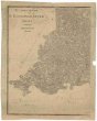
Nouvelle carte politique, militaire et routiere de l'Espagne et du Portugal
description
Mědiryt, kolor. 43,5 x 55 cm na listu 55 x 66 cm Měřítko [ca 1:2 740 000]. 5,8 cm = 25 spanische Meilen. 5,3 cm = 25 portugiesische Meilen. 5 cm = 30 lieues de France. 5,4 cm = 20 deutsche Meilen (010°27´32" z.d.--006°18´22" v.d./045°46´58" s.š.--035°19´02" s.š.)
- institution
- Mapová sbírka Přírodovědecké fakulty UK v Praze
- subcollection
- Mapová sbírka
- type
- Mapy
- alternate name
- Neue politisch-militairische Karte von Spanien und Portugal :
- subject author
- Hinrichs, J. C.
- date of issue
- 1812
- document publisher
- J.C. Hinrichs
- language
- Němčina
- origin
- Německo, Leipzig
- material
- Papír
- original owner
- Razítko Knihovna Národního muzea Praha.
- inventory number
- 1371784
next subjects
-
 Mapová sbírka Přírodovědecké fakulty UK v PrazeA. Bidschover und B. Königingratzer Kreis samt der Grafschaft Glatz
 -
 Mapová sbírka Přírodovědecké fakulty UK v PrazeMariánské Lázně
 -
 Mapová sbírka Přírodovědecké fakulty UK v PrazePodrobná mapa Království českého
 -
 Mapová sbírka Přírodovědecké fakulty UK v PrazePodrobná mapa Království českého
 -
 Mapová sbírka Přírodovědecké fakulty UK v PrazePodrobná mapa Království českého
 -
 Mapová sbírka Přírodovědecké fakulty UK v PrazePodrobná mapa Království českého
 -
 Mapová sbírka Přírodovědecké fakulty UK v PrazePodrobná mapa Království českého
 -
 Mapová sbírka Přírodovědecké fakulty UK v PrazePodrobná mapa Království českého
 -
 Mapová sbírka Přírodovědecké fakulty UK v PrazePodrobná mapa Království českého