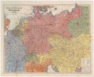
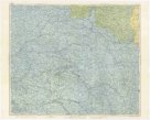
Europaeische TÜRKEY UND GRIECHENLAND
description
Oceloryt, čb. 26 x 20,5 cm, na listu 24 x 30,5 cm Měřítko 1:6 000 000. 4,3 cm = 35 geographische Meil 15=1°. 3,8 cm = 60 franz. Lieues 25=1°. 4 cm = franz. Seemeil 20=1°. 3,5 cm = 48 türkische Agash 22=1°. 3,8 cm = 140 engl. Seemil 60=1° (015°33´28" v.d.--030°20´27" v.d./045°30´36" s.š.--036°08´31" s.š.)
- institution
- Mapová sbírka Přírodovědecké fakulty UK v Praze
- subcollection
- Mapová sbírka
- type
- Mapy
- alternate name
- Meyer's Konversations-Lexikon. No. 557
- subject author
- Renner, Ltn.;Gottschalck, Adolf;Geographische Anstalt des Bibliographischen Instituts (Hildburghausen, Německo)
- dating
- 18. století, 1846
- date of issue
- 1846-1856
- document publisher
- Geographischen Anstalt des Bibliographischen Instituts
- language
- Němčina
- origin
- Německo, In Hildburghausen
- material
- Papír
- original owner
- Razítko: Státní sbírka mapová
- inventory number
- 1830460
next subjects
-
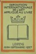 Uměleckoprůmyslové museum v PrazeExposition internationale de l'art applique au livre
 -
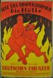 Uměleckoprůmyslové museum v PrazeFest des Simplicissimus.
 -
 Slovanská knihovnaFestival národů
 -
 Mapová sbírka Přírodovědecké fakulty UK v PrazeFlemmings Deutsch-Französisch-Russische Kriegskarte
 -
 Mapová sbírka Přírodovědecké fakulty UK v PrazeFlemmings große Spezialkarte vom belgischen und französischen Kriegsschauplatz
 -
 Uměleckoprůmyslové museum v PrazeFlüssige Tusche Dr. Fr. Schoenfeld
 -
 Uměleckoprůmyslové museum v PrazeFrühling in Wiesbaden
 -
 Uměleckoprůmyslové museum v PrazeFíková káva Jordan a Timaeus, Podmoklí
 -
 Mapová sbírka Přírodovědecké fakulty UK v PrazeGERMANIA secundum X Circulos