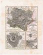
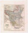
EUROP[ÄISCHE] TÜRKEI
description
Oceloryt, kolor. 17,5 x 22,5 cm, na listu 24,5 x 30,5 cm Měřítko 1:8 300 000. 3,8 cm = 20 geographische Meil., 15=1°. 4 cm = 100 türkische Berri, 66,672=1°. 4 cm = 150 russische Werst, 104,331=1° (023°41´15" v.d.--038°54´37" v.d./051°34´27" s.š.--042°54´34" s.š.)
- institution
- Mapová sbírka Přírodovědecké fakulty UK v Praze
- subcollection
- Mapová sbírka
- type
- Mapy
- alternate name
- Meyer's Konversations-Lexikon. No. 560
- subject author
- Renner;;Geographische Anstalt des Bibliographischen Instituts (Hildburghausen, Německo)
- dating
- 18. století, 1846
- date of issue
- 1846
- document publisher
- Geographischen Anstalt des Bibliographischen Instituts
- language
- Němčina
- origin
- Německo, In Hildburghausen
- material
- Papír
- original owner
- Razítko: Státní sbírka mapová
- inventory number
- 1830471
next subjects
-
 Mapová sbírka Přírodovědecké fakulty UK v PrazeEgypten oder Misir
 -
 Mapová sbírka Přírodovědecké fakulty UK v PrazeElbogner dan Saatzer Kreis und Egerische Gebiet
 -
 Mapová sbírka Přírodovědecké fakulty UK v PrazeErz-Herzogthum Oesterreich
 -
 Mapová sbírka Přírodovědecké fakulty UK v PrazeErz-Herzogthum Österreich
 -
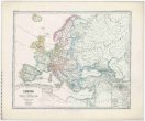 Mapová sbírka Přírodovědecké fakulty UK v PrazeEuropa nach dem Wiener Congress 1815
 -
 Mapová sbírka Přírodovědecké fakulty UK v PrazeEuropa um 1740
 -
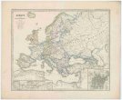 Mapová sbírka Přírodovědecké fakulty UK v PrazeEuropa zur Zeit Napoleon's I.
 -
 Mapová sbírka Přírodovědecké fakulty UK v PrazeEuropaeische TÜRKEY UND GRIECHENLAND
 -
 Mapová sbírka Přírodovědecké fakulty UK v PrazeEurope at the time of Napoleon.