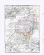
DAS ASIATISCHE RUSSLAND jenseits des Ural
description
Oceloryt, kolor. 18,5 x 25,5 cm, na listu 24,5 x 30 cm Měřítko [ca 1:28 500 000]. 2,6 cm = 100 geographische Meil. 4,3 cm = 1000 Werste (027°33´01" v.d.--148°44´02" v.d./072°40´35" s.š.--037°34´13" s.š.)
- institution
- Mapová sbírka Přírodovědecké fakulty UK v Praze
- subcollection
- Mapová sbírka
- type
- Mapy
- alternate name
- Meyer's Konversations-Lexikon. No. 672
- subject author
- Renner;;Geographische Anstalt des Bibliographischen Instituts (Hildburghausen, Německo)
- dating
- 18. století, 1846
- date of issue
- 1846
- document publisher
- Geographisch. Graviranstalt des Bibliographischen Instituts
- language
- Němčina
- origin
- Německo, In Hildburghausen
- material
- Papír
- original owner
- Razítko: Státní sbírka mapová
- inventory number
- 1830565
next subjects
-
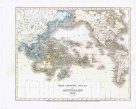 Mapová sbírka Přírodovědecké fakulty UK v PrazeDER GROSSE OCEAN und AUSTRALIEN
 -
![DIE EUROP[ÄISCHE] TÜRKEI](/data/cache/media/bc/12157536-136x110-1715760470.jpg) Mapová sbírka Přírodovědecké fakulty UK v PrazeDIE EUROP[ÄISCHE] TÜRKEI
Mapová sbírka Přírodovědecké fakulty UK v PrazeDIE EUROP[ÄISCHE] TÜRKEI -
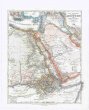 Mapová sbírka Přírodovědecké fakulty UK v PrazeDIE LAENDER des Pascha von AEgypten
 -
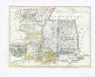 Mapová sbírka Přírodovědecké fakulty UK v PrazeDIE STAATEN von ARKANSAS
 -
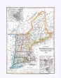 Mapová sbírka Přírodovědecké fakulty UK v PrazeDIE STAATEN von MAINE
 -
 Mapová sbírka Přírodovědecké fakulty UK v PrazeDIE STAATEN von NEW YORK
 -
![DIE STAATEN von N[ORD] & S[ÜD] CAROLINA](/data/cache/media/8f/12157592-136x110-1715760471.jpg) Mapová sbírka Přírodovědecké fakulty UK v PrazeDIE STAATEN von N[ORD] & S[ÜD] CAROLINA
Mapová sbírka Přírodovědecké fakulty UK v PrazeDIE STAATEN von N[ORD] & S[ÜD] CAROLINA -
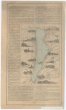 Mapová sbírka Přírodovědecké fakulty UK v PrazeDampfschiff-Fahrt auf dem Starnberger See
 -
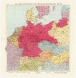 Mapová sbírka Přírodovědecké fakulty UK v PrazeDas Deutsche Reich im mitteleuropäischen Raum