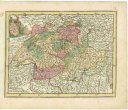
Kurfürstenthum HESSEN
description
Oceloryt, kolor. 24 x 18 cm, na listu 30 x 25 cm Měřítko [ca 1:1 890 000]. 4,2 cm = 5 geograph. Meilen 15=1° (009°04´53" v.d.--010°10´28" v.d./051°21´07" s.š.--049°57´49" s.š.)
- institution
- Mapová sbírka Přírodovědecké fakulty UK v Praze
- subcollection
- Mapová sbírka
- type
- Mapy
- alternate name
- Meyer's Konversations-Lexikon. No. 785
- subject author
- Renner;Ehricht, C.;Geographische Anstalt des Bibliographischen Instituts (Hildburghausen, Německo)
- dating
- 18. století, 1848
- date of issue
- 1848
- document publisher
- Geographischen Anstalt des Bibliographischen Instituts
- language
- Němčina
- origin
- Německo, In Hildburghausen
- material
- Papír
- original owner
- Razítko: Státní sbírka mapová
- inventory number
- 1830995
next subjects
-
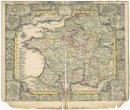 Mapová sbírka Přírodovědecké fakulty UK v PrazeLe royaume de France et les conquetes de Louis de Grand
 -
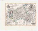 Mapová sbírka Přírodovědecké fakulty UK v PrazeMECKLENBURG
 -
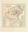 Mapová sbírka Přírodovědecké fakulty UK v PrazeMapa W. Ks. Poznańskiego
 -
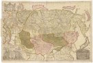 Mapová sbírka Přírodovědecké fakulty UK v PrazeNova descriptio geographica Tattariae magnae tam orientalis quam occidentalis in particularibus et generalibus territoriis una cum delineatione totius imperii Russici imprimis Siberiae accurate ostensa
 -
 Mapová sbírka Přírodovědecké fakulty UK v PrazeNovissima Foederatorum HELVETIORUM Tabula
 -
 Mapová sbírka Přírodovědecké fakulty UK v PrazeObjektive Karte der Bevölkerungsvertheilung in Oberfranken
 -
Mapová sbírka Přírodovědecké fakulty UK v PrazeOesterreichisch-russisch-türkischer Kriegsatlas
-
 Mapová sbírka Přírodovědecké fakulty UK v PrazeOriginalkarte der Insel Korfu
 -
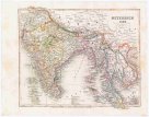 Mapová sbírka Přírodovědecké fakulty UK v PrazeOstindien