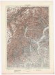
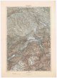
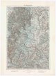
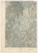
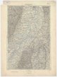
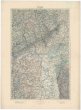
Neueste Karte des Erzherzogthums Oesterreich ob und unter der Enns
description
Kolor., podlepena plátnem 55 x 89,5 cm na listu 58 x 93 cm, slož. na 58 x 47 cm Měřítko [ca 1:280 000]. 13,7 cm = 5 deutsche geographischen Meilen, 15 auf einen Grad des Aequators (012°38´57" v.d.--017°09´38" v.d./049°02´55" s.š.--047°24´20" s.š.)
- institution
- Mapová sbírka Přírodovědecké fakulty UK v Praze
- subcollection
- Mapová sbírka
- type
- Mapy
- subject author
- Derichs, Martin Joseph Ritter von
- date of issue
- 1800
- document publisher
- bey Artaria
- language
- Němčina
- origin
- Rakousko, Wien
- material
- Papír
- original owner
- Razítko BEC.
- inventory number
- 1297014
similar subjects
-
 Mapová sbírka Přírodovědecké fakulty UK v Praze26°44° Savona
 -
 Mapová sbírka Přírodovědecké fakulty UK v Praze26°44° Savona
 -
 Mapová sbírka Přírodovědecké fakulty UK v Praze26°45° Alessandria
 -
 Mapová sbírka Přírodovědecké fakulty UK v Praze26°46° Varese
 -
 Mapová sbírka Přírodovědecké fakulty UK v Praze26°47° Zürich
 -
 Mapová sbírka Přírodovědecké fakulty UK v Praze26°48° Schaffhausen
 -
 Mapová sbírka Přírodovědecké fakulty UK v Praze26°48° Schaffhausen
 -
 Mapová sbírka Přírodovědecké fakulty UK v Praze26°49° Karlsruhe
 -
 Mapová sbírka Přírodovědecké fakulty UK v Praze26°50° Mainz