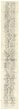
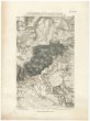
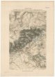
Topographische Reisekarte durch die umliegende Gegend von Dresden
description
Čb., podlepena plátnem 20 x 35 cm na listu 22 x 35,5 cm Měřítko [ca 1:200 000]. 4,7 cm = 12000 Ellen (013°26´10" v.d.--014°09´16" v.d./051°13´17" s.š.--050°50´21" s.š.)
- institution
- Mapová sbírka Přírodovědecké fakulty UK v Praze
- subcollection
- Mapová sbírka
- type
- Mapy
- subject author
- Keyl, Carl
- date of issue
- 1804
- document publisher
- Arnoldischen Buch- und Kunsthandlung
- language
- Němčina
- origin
- Německo, [Dresden]
- material
- Papír
- original owner
- Státní sbírka mapová Republiky československé
- inventory number
- 1354636
similar subjects
-
 Mapová sbírka Přírodovědecké fakulty UK v PrazeNeue Himelsbelchreibung
 -
 Mapová sbírka Přírodovědecké fakulty UK v PrazeDie Berge und ihre Höhen
 -
 Mapová sbírka Přírodovědecké fakulty UK v PrazeDas Heilige Land aus der Vogelschau
 -
 Mapová sbírka Přírodovědecké fakulty UK v PrazePanorama der Elbe von Aussig bei Riesa
 -
 Mapová sbírka Přírodovědecké fakulty UK v PrazeLager für 18 Bataillone Infanterie des 4 Armee Corps bei Rothensee 1833
 -
 Mapová sbírka Přírodovědecké fakulty UK v PrazePlan der Festung Tortosa
 -
 Mapová sbírka Přírodovědecké fakulty UK v PrazeGefechtsstellungen der Russen und Franzosen zwischen Nollendorf und Hohenstein im Böhmen 29 Aug. 1813
 -
 Mapová sbírka Přírodovědecké fakulty UK v PrazeAufstellung der Alliirten und der Franzosen zur Schlacht bei Kulm am 30. Aug: 1813
 -
 Mapová sbírka Přírodovědecké fakulty UK v PrazeSituations Plan der Stadt Leipzig und deren Umgebungen