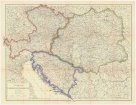
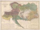
Karte der Österreichischen Monarchie
description
Barev. 30 x 41,3 cm na listu 33,3 x 44,4 cm Měřítko [ca 1:3 500 000]. 7,4 cm = 35 geographischen Meilen 15 auf 1 Grad (007°46´41" v.d.--026°53´40" v.d./051°07´27" s.š.--041°50´12" s.š.)
- institution
- Mapová sbírka Přírodovědecké fakulty UK v Praze
- subcollection
- Mapová sbírka
- type
- Mapy
- subject author
- Biller, Dominic
- date of issue
- 1840-1850
- document publisher
- Florian Mollo
- language
- Němčina
- origin
- Rakousko, In Wien
- material
- Papír
- original owner
- Museum regni Bohemiae
- inventory number
- 1375608
similar subjects
-
 Mapová sbírka Přírodovědecké fakulty UK v PrazeAus meiner Dienstzeit 1906-1918.
 -
 Mapová sbírka Přírodovědecké fakulty UK v PrazeTriaskarte der Habsburger Monarchie
 -
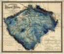 Mapová sbírka Přírodovědecké fakulty UK v PrazeSchulwandkarte vom Königreich Böhmen
 -
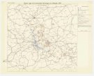
 Mapová sbírka Přírodovědecké fakulty UK v PrazeG. Freytags Verkehrs-Karte von Österreich-Ungarn
 -
 Mapová sbírka Přírodovědecké fakulty UK v PrazeEthnographische Karte der Oesterreichischen Monarchie
 -
 Mapová sbírka Přírodovědecké fakulty UK v PrazeLechner's Eisenbahn- und Strassenkarte von Österreich-Ungarn
 -
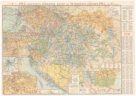
Mapová sbírka Přírodovědecké fakulty UK v PrazeJ. G. Rothauga fysikální a školní mapa Říše rakousko-uherské a zemí sousedních
-
 Mapová sbírka Přírodovědecké fakulty UK v PrazeŠkolní mapa Království českého
 -
 Mapová sbírka Přírodovědecké fakulty UK v PrazeRakousko-uherské mocnářství