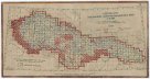
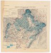
Karte über die Circulation der böhmischer Braunkohle während des Jähres 1869
description
Kolor. litografie 48,5 x 67,5 cm na listu 57 x 75 cm + Měřítko neuvedeno (010°29´50" v.d.--017°37´19" v.d./052°44´46" s.š.--049°00´58" s.š.)
- institution
- Mapová sbírka Přírodovědecké fakulty UK v Praze
- subcollection
- Mapová sbírka
- type
- Mapy
- subject author
- Pechar, Johann
- date of issue
- 1870
- document publisher
- C.H. Hunger
- language
- Němčina
- origin
- Hlavní město Praha, In Prag
- material
- Papír
- inventory number
- 1391586
similar subjects
-
 Mapová sbírka Přírodovědecké fakulty UK v PrazePřehled listů původního vyměřování
 -
 Mapová sbírka Přírodovědecké fakulty UK v PrazeSněhoměrná mapa povodí Moravy a čs Odry
 -
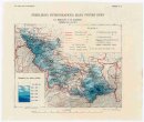 Mapová sbírka Přírodovědecké fakulty UK v PrazePřehledná hydrografická mapa povodí Odry na Moravě a ve Slezsku
 -
 Mapová sbírka Přírodovědecké fakulty UK v PrazePřehledná hydrografická mapa povodí Odry na Moravě a ve Slezsku
 -
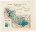
 Mapová sbírka Přírodovědecké fakulty UK v PrazePřehledná hydrografická mapa povodí Moravy
 -
 Mapová sbírka Přírodovědecké fakulty UK v PrazePřehledná hydrografická mapa povodí Moravy
 -
 Mapová sbírka Přírodovědecké fakulty UK v PrazePřehledná hydrografická mapa povodí Moravy
 -
 Mapová sbírka Přírodovědecké fakulty UK v PrazePřehledná hydrografická mapa povodí Dunaje a Visly na Slovensku a v Podkarpatské Rusi
 -
 Mapová sbírka Přírodovědecké fakulty UK v PrazePřehledná hydrografická mapa povodí Dunaje a Visly na Slovensku a v Podkarpatské Rusi