Pilot chart of the North Atlantic Ocean
description
Barev. 52 x 79 cm na listu 61 x 87 cm Měřítko [ca 1:11 300 000] (099°08´26" z.d.--009°50´37" v.d./062°06´13" s.š.--002°59´12" j.š.)
- institution
- Mapová sbírka Přírodovědecké fakulty UK v Praze
- subcollection
- Mapová sbírka
- type
- Mapy
- subject author
- Spojené státy americké
- date of issue
- 1895
- document publisher
- Hydrographic Office
- language
- Angličtina
- origin
- USA, Washington, D. C.
- material
- Papír
- original owner
- Razítko Geographisches Institut der deutschen Universität in Prag
- inventory number
- 1611698
similar subjects
-
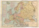 Mapová sbírka Přírodovědecké fakulty UK v PrazeMap of New Europe
 -
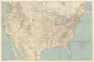 Mapová sbírka Přírodovědecké fakulty UK v PrazeThe United States and adjoining portions of Canada and Mexico
 -
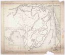 Mapová sbírka Přírodovědecké fakulty UK v PrazeKarta Amurského a Přímorského kraje
 -
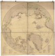 Mapová sbírka Přírodovědecké fakulty UK v PrazeThe Arctic Regions.
 -
Mapová sbírka Přírodovědecké fakulty UK v PrazeMap of the United States and Territories
-
 Mapová sbírka Přírodovědecké fakulty UK v PrazeTopographical drawings
 -
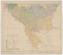 Mapová sbírka Přírodovědecké fakulty UK v PrazeEthnographic map of the Balkan Peninsula
 -
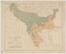 Mapová sbírka Přírodovědecké fakulty UK v PrazeZones of civilization of the Balkan Peninsula
 -
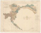 Mapová sbírka Přírodovědecké fakulty UK v PrazeAustria