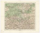
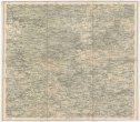
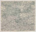
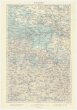
Karte von Königreich Ungarn und den zugehörigen Nebenländern
description
Oceloryt, barev., podlepena plátnem 45,5 x 64,5 cm na listu 48,5 x 67,5 cm Měřítko [ca 1:1 887 000]. 9,8 cm = 25 geographischen od. deutschen Meilen 15 auf 1 Grad (013°07´03" v.d.--026°57´37" v.d./049°51´33" s.š.--044°06´40" s.š.)
- institution
- Mapová sbírka Přírodovědecké fakulty UK v Praze
- subcollection
- Mapová sbírka
- type
- Mapy
- subject author
- Schmitfeldt, Georg;
- date of issue
- 1834
- document publisher
- Florian Mollo
- language
- Němčina
- origin
- Rakousko, Wien
- material
- Papír
- inventory number
- 1377838
similar subjects
-
 Mapová sbírka Přírodovědecké fakulty UK v PrazeŽitomir
 -
 Mapová sbírka Přírodovědecké fakulty UK v PrazeŽitomir
 -
 Mapová sbírka Přírodovědecké fakulty UK v PrazeŽitomir
 -
 Mapová sbírka Přírodovědecké fakulty UK v PrazeŻytomir
 -
 Mapová sbírka Přírodovědecké fakulty UK v PrazeŻytomir
 -
 Mapová sbírka Přírodovědecké fakulty UK v PrazeŻydaczów und Stryj
 -
 Mapová sbírka Přírodovědecké fakulty UK v PrazeŻydaczów und Stryj
 -
 Mapová sbírka Přírodovědecké fakulty UK v PrazeŻydaczów und Stryj
 -
 Mapová sbírka Přírodovědecké fakulty UK v PrazeŻołkiew