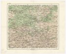
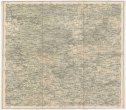
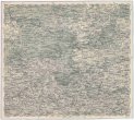
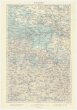
Topographische Karte der Oesterreichischen Monarchie mit Angabe aller Post-Strassen
description
Oceloryt, barev., podlepena plátnem 103 x 134,5 cm na listu 109 x 141 cm, složeno na 14 x 18,5 cm v papírovém pouzdře 19 x 15 cm Měřítko [ca 1:1 100 000]. 13,8 cm = 20 geographische Meilen 15 auf 1 Grad = milles geographiques 15 au degré (008°02´31" v.d.--026°20´42" v.d./051°46´53" s.š.--041°49´13" s.š.)
- institution
- Mapová sbírka Přírodovědecké fakulty UK v Praze
- subcollection
- Mapová sbírka
- type
- Mapy
- alternate name
- Carte topographique et itinéraire de la Monarchie Autrichienne
- subject author
- Möller, G.;Pilsak, F.;Artaria & Fontaine
- date of issue
- 1822
- document publisher
- bey Tranquillo Mollo
- language
- Němčina
- origin
- Rakousko, In Wien
- material
- Papír
- original owner
- Razítko Státní sbírka mapová Republiky československé.
- inventory number
- 1384169
similar subjects
-
 Mapová sbírka Přírodovědecké fakulty UK v PrazeŽitomir
 -
 Mapová sbírka Přírodovědecké fakulty UK v PrazeŽitomir
 -
 Mapová sbírka Přírodovědecké fakulty UK v PrazeŽitomir
 -
 Mapová sbírka Přírodovědecké fakulty UK v PrazeŻytomir
 -
 Mapová sbírka Přírodovědecké fakulty UK v PrazeŻytomir
 -
 Mapová sbírka Přírodovědecké fakulty UK v PrazeŻydaczów und Stryj
 -
 Mapová sbírka Přírodovědecké fakulty UK v PrazeŻydaczów und Stryj
 -
 Mapová sbírka Přírodovědecké fakulty UK v PrazeŻydaczów und Stryj
 -
 Mapová sbírka Přírodovědecké fakulty UK v PrazeŻołkiew