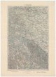
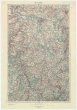
Historisch-geographisch-statistisch-gefaellsaemtliche KARTE vom Königreiche Böhmen
description
Kolor., podlepena plátnem 26,5 x 33,5 cm na listu 45,5 x 68 cm Měřítko [ca 1:1 040 000]. 5 cm = 7 geograph. Meilen = 7 post Meilen (012°00´29" v.d.--016°49´32" v.d./051°05´23" s.š.--048°30´33" s.š.)
- institution
- Mapová sbírka Přírodovědecké fakulty UK v Praze
- subcollection
- Mapová sbírka
- type
- Mapy
- subject author
- Bastien, Joseph;Mayregg, Cajetan von
- date of issue
- 1831
- document publisher
- Cajetan von Mayregg
- language
- Němčina
- origin
- Hlavní město Praha, Prag
- material
- Papír
- inventory number
- 001500740
similar subjects
-
 Mapová sbírka Přírodovědecké fakulty UK v Praze28°51° Meiningen
 -
 Mapová sbírka Přírodovědecké fakulty UK v Praze29°50° Bamberg
 -
 Mapová sbírka Přírodovědecké fakulty UK v Praze3 Tage in Prag
 -
 Mapová sbírka Přírodovědecké fakulty UK v Praze30°49° Kleneč pod Čerchovem
 -
 Mapová sbírka Přírodovědecké fakulty UK v Praze30°49° Kleneč pod Čerchovem
 -
 Mapová sbírka Přírodovědecké fakulty UK v Praze30°49° Kleneč pod Čerchovem
 -
 Mapová sbírka Přírodovědecké fakulty UK v Praze30°50° Cheb
 -
 Mapová sbírka Přírodovědecké fakulty UK v Praze30°50° Cheb
 -
 Mapová sbírka Přírodovědecké fakulty UK v Praze30°51° Leipzig